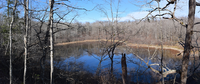
Baker's Pond Trail in Holly Springs National Forest
Baker's Pond, located in Holly Springs National Forest in northern Mississippi, is a spring-fed pond that is the source of the Wolf River. There is (as of January 2019) a ~0.5 mile (one-way) trail that gains about 150 feet of elevation (round trip) to the lake.
The trail starts at a trailhead not far off the south side of U.S. Highway 72. Accessing the trailhead requires driving down a well-maintained dirt road that is passable in any vehicle. There is small parking area at the trailhead, as well as a sign mentioning the importance of restoring the forest.
The trail was originally about a 2.5 mile loop that appears to have followed the road at some point according to this U.S. Forest Service map. However, in December 2015 an EF-4 tornado passed through the area just south of the pond and completely destroyed all of the forest in its path. Since that time the trail has been an out-and-back trail that ends on the south side of Baker's Pond.
The trail itself is an easy walk that begins by gently descending a small hill from the trailhead to the north side of the pond. Near the pond, the trail turns uphill and goes along the small hill on the west side of the pond and you must find your way around a few trees before descending back towards the south end of the pond. From this point any part of what was formerly the trail is not only impassible, but also unfindable as the ground is entirely covered in downed trees.
I have no idea if someday the trail will be rebuilt or a new trail will be constructed. Additionally, the trail itself never actually goes to the pond shore, and much of the pond is surrounded by fairly dense vegetation. The trail is open and accessible year-round, and there is no access fee.
See my recording on AllTrails here.
I have more photos of Baker's Pond and Holly Springs National Forest in this album on Google Photos.
© Copyright 2007–2019 Matthew Pintar. All rights reserved.

 |
| Baker's Pond from the hill to it's south |
The trail starts at a trailhead not far off the south side of U.S. Highway 72. Accessing the trailhead requires driving down a well-maintained dirt road that is passable in any vehicle. There is small parking area at the trailhead, as well as a sign mentioning the importance of restoring the forest.
The trail was originally about a 2.5 mile loop that appears to have followed the road at some point according to this U.S. Forest Service map. However, in December 2015 an EF-4 tornado passed through the area just south of the pond and completely destroyed all of the forest in its path. Since that time the trail has been an out-and-back trail that ends on the south side of Baker's Pond.
 |
| The trailhead |
The trail itself is an easy walk that begins by gently descending a small hill from the trailhead to the north side of the pond. Near the pond, the trail turns uphill and goes along the small hill on the west side of the pond and you must find your way around a few trees before descending back towards the south end of the pond. From this point any part of what was formerly the trail is not only impassible, but also unfindable as the ground is entirely covered in downed trees.
 |
| Tornado damage at the end of the trail |
I have no idea if someday the trail will be rebuilt or a new trail will be constructed. Additionally, the trail itself never actually goes to the pond shore, and much of the pond is surrounded by fairly dense vegetation. The trail is open and accessible year-round, and there is no access fee.
See my recording on AllTrails here.
I have more photos of Baker's Pond and Holly Springs National Forest in this album on Google Photos.
 |
| The trail passes near the north side of the pond before heading uphill off to the right of the photo |
© Copyright 2007–2019 Matthew Pintar. All rights reserved.


Comments
Post a Comment